 The Frisco Railroad Bridge (1892), the Harahan Railroad Bridge (1916) and the I-55 Memphis-Arkansas Memorial Bridge (1949) at Memphis, Tennessee.
Unknown Arkansas Fault Can Trigger Magnitude 7 Earthquake
A previously unknown fault in eastern Arkansas could trigger a magnitude 7 earthquake with an epicenter near a major natural gas pipeline, a scientist said Wednesday.
Haydar Al-Shukri, the director of the Arkansas Earthquake Center at the University of Arkansas at Little Rock, said the fault is separate from the New Madrid fault responsible for a series of quakes in 1811-12 that caused the Mississippi River to flow backward.
Acres of cotton fields cover the fault west of Marianna, about 100 miles east of Little Rock, but stretches of fine sand mixed with fertile soil gave away the fault's location, Al-Shukri said. Liquefied sand bubbled up through cracks in the earth, while ground radar and digs showed vents that let the sand reach the surface, he said.
The fault, likely created in the last 5,000 years, sparked at least one magnitude 7 earthquake in its history. Such temblors cause massive destruction in their wake.
"This is a very, very dangerous (area) at risk of earthquake," Al-Shukri said. "When you talk about (magnitude) 7 and plus, this is going to be a major disaster."
Al-Shukri did not identify a time frame for the potential earthquake.
Such a quake would affect Little Rock and neighboring states such as Tennessee and Mississippi, Al-Shukri said.
"Affect"?
AFFECT?!?!?
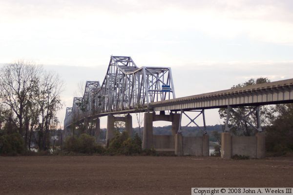 U.S. Rte. 49 bridge at Helena, AR. Compared to the Memphis bridges above, it is a youngster, having been opened for traffic in 1961.
I've got news for you. I did a lot of running around Lee County, Arkansas during the late 80s when I was looking for a Civil War-era steamboat wreck with the help of a nautical archaeologist so I know the terrain. Take a look at a map that shows eastern Arkansas, northwestern Mississippi and West Tennessee. A 7.0 quake in Marianna would drop or severely damage all the bridges (at least) from Helena, AR to above Memphis, including critical railway bridges and I-40 and I-55.
 The I-40 Hernando De Soto Bridge (1973) at Memphis.
Memphis is home to four bridges that cross the Mississippi River into Arkansas, and one of them, the Frisco Railroad Bridge is over 100 years old, having been built in 1892. Running alongside the Frisco is the Harahan Railroad Bridge, built in 1916 and the Memphis-Arkansas Memorial Bridge, built in 1949. The fourth, the Hernando de Soto Bridge was built in 1973 and is still referred to by the locals as the "new bridge." (Rosey was born and raised in West Memphis, Arkansas.)
Not only would this disrupt east-west road and rail traffic, but the wreckage would bottle up all north-south barge traffic above and below Memphis-Helena.
The economic effect alone of these bridge collapses would be catastrophic, even absent any other infrastructure damage -- which of course would be considerable as well. Memphis would become uninhabitable overnight. And that's even if it didn't trigger a sympathetic quake along the New Madrid fault.
"Affect" indeed.
Mike
III
5 comments:
Bracken touched on this possibility in his third book as well. As far as I'm concerned, barring a nuclear or EMP attack, this is the worst case scenario for the "just in time" supply system to urban areas. You think it took them a long time to fix the oil leak? Try waiting on a federal tax force while the monkeys (viz Baugh) get hungry and angry all around you.
If memory serves me, Bracken referred to Memphis as "Mogadishu on the Mississippi". Picture thta.
Just another pleasant thought entertained on this website.
And if the New Madrid goes like it did the last time, I'd expect the Old River Control Structure to fail as well, allowing the Mississippi to shift to the west and exit to the Gulf at Morgan City. Unless the bridges on the Atchafalaya were designed to handle that sort of flow, you can add I-10 & US-90 to the major highways cut.
Membabwe is sat on a thick pile of poorly consolidated, wet sand.
Liquifaction (when loose wet sand or silt is shaken, it's structure collapses and it becomes liquid) was the major problem in Kobe.
Accounts of the 1812 quakes speak of mud and sand volcanoes and the formation of large shallow lakes as loose sediments liquified and subsided.
Membabwe is a major distribution hub.
FBC
Post a Comment